How to get here even if you can't read a map
Maps, directions, GPS...
No, the sign in Gastown looked nothing like this. Their’s was far more elegant.
Phone first This is a small operation. If you get here, and I'm off to Beaumont doing a delivery, you either get to twiddle your thumbs for two hours or you need to come back later. If I'm in back it's a 3 million square foot back yard. Then you get to ask the cat for directions. He's noted for giving very bad directions.
Trailers Turning more than a 12 foot trailer around at the house can be tricky. If you are bringing a trailer, use the north (potyard) entrance, go up until you have trees on both sides of the road, and check in at the house on the left side
Because different people think in different ways,
here are several methods to get to our door.
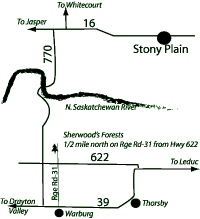
For those of you who read maps:
... and for those of you who prefer verbal directions.
From the West End of Edmonton...
Go west on either 16 or 16A.
After they merge west of Stony Plain you will go past a junction with Highway 43, going north to Whitecourt. Shortly after this there is a small sign to "Mink Lake, Carvel, Genesee" It should also be labeled Highway 770
Turn left (south) onto Secondary highway 770.
This will be a left turn off of Highway 16 onto Secondary Highway 770.
There isn't much of a turning lane, watch for semi's driving up your
tailpipe. Go south on 770. You will pass the turnoffs to Carvel, Mink Lake,
Keephills (Secondary 627). Keep going.
You will go down a big dip, and cross the North Saskatchewan River. Keep going.
You will pass turnoffs for MECCS School, and for the Genesee Power plant. Keep going.
You will see a tiny town, St. Francis. It's marked with a '70 kph' speed limit sign. From this side you see a closed gas station/convenience store, and little else. Just after the closed gas station 770 crosses Secondary 622.
Turn left (east) onto Secondary 622.
Go 1 mile (1.6 kilometres) to Range Road 31. It's a moderately steep hill and Rng Rd 31 has been known to sneak up on people. If you are pulling a trailer, take care. Range Road 31 is a gravel road.
Turn left. (North) on Rng Rd 31
House Driveway: Go 1/2 mile (.8 km) to the first driveway on your left. There is a sign. The house is set back from the road and is a grey blue colour and hard to see from the entrance. But we have a handsome sign to tell you that you have found us.
Potyard: If you are picking up trees, go to the field entrance, next left. There will be a gate by the pond. There is a blue barrel north of the entrance to mark it. If I'm expecting you, the gate will be open. Drive in, and go up the access road until you cross the second cattle guard. Turn left, and go across the field to the pot yard.
From the South End of Edmonton
Go south on Calgary Trail.
Go the the last exit for Leduc. It is marked for Drayton Valley, Highway 39.
Exit right (west) toward Drayton Valley, Highway 39
You will pass the junction to Highway 60, Devon. Keep going.
You will pass through the thriving town of Calmar.
The local police enforce the speed limit of 50 with some enthusiasm.
Continue out of town.
Watch for a sign for Telfordville, St. Francis, Secondary Highway 622.
Turn right (briefly north) onto Secondary 622.
This is a right turn, followed by a sweeping bend that leaves you still heading west, while 39, the highway you just left turns to the South. Go past the turnoff for Telfordville. You will go through a large dip when crossing Strawberry Creek. Keep going.
Start watching the range road signs at the corners. The roads are numbered strangely if you aren't used to country life. There is no Range Road 26, 27, 28, or 29. Rng Rd 30 is right after Rng Rd 25. This catches some people by surprise.
At Rge Rd 31, turn right. (north)
Go north for .8 km (1/2 mile)
First driveway on left.
Driveway entrance is marked with a sign and a blue barrel.
Google Link
Red balloon pin southwest of Edmonton. Google Map Link
Caution using our municipal address: (50042 Range Road 31, Warburg, AB) Google has become erratic about plotting rural addresses. We had several people hunting south of Warburg. If you use it with an in-car nav system like Tom-Tom, you may get directed to the village of Warburg. As a sanity check, our farm is 1.5 miles (2.4 km) from St. Francis, AB. Now St. Francis isn't much: An abandoned gas station, a graveyard with no church and a scattering of houses. But it's the junction of Secondary Highways 770 and 622, and so is a paved cross road. We're one road east, and .8 km north.
Searching on Google Maps
WARNING Google Maps knows where we are. But you have to spell it right: Sherwood's Forests Tree Farm. Get all 4 s's in there. Get the apostrophy. If you have a smart phone, you're set. Google is getting better, and making more intelligent guesses, but do your sanity checks.
Bing Maps
I have had interesting experiences with customers getting misdirected with Bing maps, likely due to my errors. The link below shows a map from Edmonton to our farm. Change the start point as needed. Without the Edmonton, it shows a dot in the middle of nowhere with no context. Time from Henday either on the west end or the south side is about 45 minutes.
Bing, as of 3 May 2020 tried to route you through a corner of the Genesee coal mine when you were 5 km north of St. Francis. I trust your common sense will prevail. Stay on 770 all the way to 622.
Searching on bing maps seems to work consistently. Please let me know if you have problems.
In car GPS
MANY in car GPS's do NOT understand rural municipal addresses and will take you to Warburg. If you have such a GPS, tell it to go to St. Francis instead. From St. Francis you can follow the tail end of the West End of Edmonton directions.
Using Latitude and Longitude.
Latitude 53.288262 Longitude -114.320102
(Don't get too wrapped up in the figures. By the third decimal place you are within a tenth of a km. 6 decimal places puts you within a few centimeters.)
Please let me know of problems. Ideally tell me:
- What device (desktop, phone)
- What operating system (Windows, Mac, iOS, Android)
- What browser (Safari, MS Explorer, MS Edge, Chrome, Firefox...)
- What you did
- Where it tried to lead you.
Got something to say? Email me: sfinfo@sherwoods-forests.com
Interesting? Share this page.
![]() Share
Share
Want to talk right now? Talk to me: (8 am to 8 pm only, please) 1-780-848-2548
Back to Top
Copyright © 2008 - 2018 S. G. Botsford
Sherwood's Forests is located about 75 km southwest of Edmonton, Alberta. Please refer to the map on our Contact page for directions.